Winter storm could impact holiday travel later this week
…Significant Winter Storm and Extreme Cold Mid to Late Week…
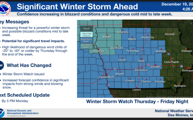
.A powerful winter storm will cross the region over the middle to latter portions of the week. Confidence is increasing in the potential for a significant multi-faceted event including possible blizzard conditions and extreme cold across central Iowa. Forecast snow accumulations remain uncertain at this time, but changes in projected snow totals will not preclude the potential for blizzard conditions due to strong winds and blowing snow which would render travel dangerous to impossible. Extreme cold is highly likely as wind chills fall to 20 to 40 below zero or colder from Thursday through the end of the week.
Those with holiday travel interests from late Wednesday through the end of the week are strongly encouraged to pay close attention for forecast updates and be prepared to consider alternative plans.
442 AM CST Mon Dec 19 2022
…WINTER STORM WATCH REMAINS IN EFFECT FROM THURSDAY MORNING THROUGH LATE FRIDAY NIGHT…
* WHAT…Snow and blowing snow. Winds could gust as high as 40 to 50 mph. Blizzard conditions possible. Extreme cold wind chills likely.
* WHERE…All of central Iowa.
* WHEN…From Thursday morning through late Friday night.
* IMPACTS…Areas of blowing snow could significantly reduce visibility. The hazardous conditions could impact the morning or evening commute. The dangerously cold wind chills as low as 40 below zero could cause frostbite on exposed skin in as little as 10 minutes.
PRECAUTIONARY/PREPAREDNESS ACTIONS…
Monitor the latest forecasts for updates on this situation.
For the latest