Winter isn’t over yet — Winter Storm Watch Thursday, 5-8″ forecast
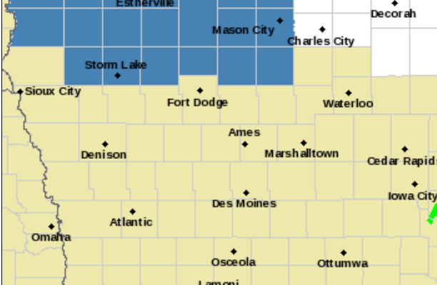
…Heavy Snowfall Expected Across Portions of Northern Iowa
Thursday into Friday…
.A winter storm is expected to impact Iowa later this week. The
highest snowfall totals are expected in the northern third of the
state. Totals diminish further south where rain becomes more likely.
While the heaviest snow doesn`t start until Thursday afternoon,
there will be intermittent light rain and snow beginning late
tonight into Wednesday night but with only minor amounts expected.
IAZ004>007-015>017-023>026-071745-
/O.NEW.KDMX.WS.A.0005.230309T1800Z-230310T1200Z/
Emmet-Kossuth-Winnebago-Worth-Palo Alto-Hancock-Cerro Gordo-
Pocahontas-Humboldt-Wright-Franklin-
Including the cities of Estherville, Algona, Forest City,
Lake Mills, Northwood, Manly, Emmetsburg, Garner, Britt, Kanawha,
Mason City, Clear Lake, Pocahontas, Laurens, Rolfe, Fonda,
Gilmore City, Humboldt, Eagle Grove, Clarion, Belmond,
and Hampton
338 AM CST Tue Mar 7 2023
…WINTER STORM WATCH IN EFFECT FROM THURSDAY AFTERNOON THROUGH LATE THURSDAY NIGHT…
* WHAT…Heavy snow possible. Total snow accumulations of 5 to 8
inches possible. Strong winds may produce blowing snow as well,
reducing visibilities.
* WHERE…Portions of northern Iowa.
* WHEN…From Thursday afternoon through early Friday morning.
* IMPACTS…Travel could be very difficult. Patchy blowing snow
could significantly reduce visibility. The hazardous conditions
could impact the evening commute.
PRECAUTIONARY/PREPAREDNESS ACTIONS…
Monitor the latest forecasts for updates on this situation.
For the latest