Season’s first winter storm to hit our area starting today
FOR THE LATEST WEATHER INFORMATION, CLICK HERE
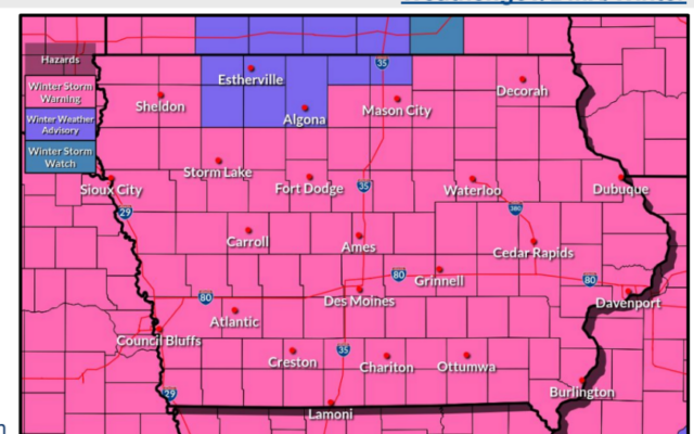
MASON CITY — The first major snowfall of the season is expected today and tomorrow as Winter Storm Warnings are in effect for most of our listening area this afternoon through Tuesday:
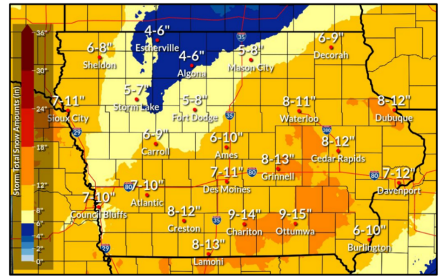
Moderate to heavy snow will spread across Iowa through the day today and last into Tuesday before exiting eastward Tuesday evening. Highest accumulations remain forecast across roughly the southeast half of Iowa, where widespread amounts of 6 to 12 inches or more may occur. As snow ends Tuesday afternoon, winds will increase with gusts of 35 to 40 mph or greater possible. This could result in a period of blowing and drifting snow even without falling snow
====
Hancock-Cerro Gordo-Humboldt-Wright-
Including the cities of Garner, Britt, Kanawha, Mason City, Clear Lake, Pocahontas, Laurens, Rolfe, Fonda, Gilmore City, Humboldt, Eagle Grove, Clarion, and Belmond
247 AM CST Mon Jan 8 2024
…WINTER STORM WARNING IN EFFECT FROM 3 PM THIS AFTERNOON TO 6 PM CST TUESDAY…
* WHAT…Heavy snow expected. Total snow accumulations of 5 to 9 inches. Winds gusting as high as 40 mph by Tuesday afternoon.
* WHERE…Northern Iowa
* WHEN…From 3 PM this afternoon to 6 PM CST Tuesday.
* IMPACTS…Plan on slick snow covered road conditions. Any blowing snow could significantly reduce visibility. Hazardous conditions could impact the Monday evening and Tuesday morning commutes.
====
Franklin-Butler
247 AM CST Mon Jan 8 2024
…WINTER STORM WARNING NOW IN EFFECT FROM 3 PM THIS AFTERNOON TO 6 PM CST TUESDAY…
* WHAT…Heavy snow expected. Total snow accumulations of 6 to 12 inches. Blowing snow with winds gusting as high as 40 mph by Tuesday afternoon.
* WHERE…Central and Southern Iowa.
* WHEN…From 3 PM this afternoon to 6 PM CST Tuesday.
* IMPACTS…Travel will likely be very difficult at times. Patchy blowing snow could significantly reduce visibility. Hazardous conditions will impact the Monday evening and Tuesday morning commutes.
====
Mitchell-
Including the city of Osage
234 AM CST Mon Jan 8 2024
…WINTER STORM WARNING IN EFFECT FROM 6 PM THIS EVENING TO 6 AM CST WEDNESDAY…
* WHAT…Heavy snow expected. Total snow accumulations of 5 to 7 inches. Winds gusting as high as 35 mph.
* WHERE…Mitchell County.
* WHEN…From 6 PM this evening to 6 AM CST Wednesday.
* IMPACTS…Travel could be very difficult. The hazardous conditions could impact the morning or evening commute.
====
Floyd-Chickasaw-Fayette-
Including the cities of Charles City, New Hampton, and Oelwein
234 AM CST Mon Jan 8 2024
…WINTER STORM WARNING IN EFFECT FROM 6 PM THIS EVENING TO 6 AMCST WEDNESDAY…
* WHAT…Heavy snow expected. Total snow accumulations of 7 to 10 inches. Winds gusting as high as 40 mph.
* WHERE…Floyd, Chickasaw and Fayette Counties.
* WHEN…From 6 PM this evening to 6 AM CST Wednesday.
* IMPACTS…Travel could be very difficult. The hazardous conditions could impact the morning or evening commute.
====
Kossuth-Winnebago-Worth
Including the cities of Estherville, Algona, Forest City, Lake Mills, Northwood, Manly, and Emmetsburg
247 AM CST Mon Jan 8 2024
…WINTER WEATHER ADVISORY NOW IN EFFECT FROM 3 PM THIS AFTERNOON TO 6 PM CST TUESDAY…
* WHAT…Snow expected. Total snow accumulations of 3 to 5 inches. Blowing snow with winds gusting as high as 40 mph by Tuesday.
* WHERE…North Central Iowa.
* WHEN…From 3 PM this afternoon to 6 PM CST Tuesday.
* IMPACTS…Plan on slick road conditions. Patchy blowing snow could significantly reduce visibility. Hazardous travel conditions could impact the Monday evening and Tuesday morning commutes.
For the latest