Blizzard Warnings Thursday afternoon through Saturday morning, extreme cold expected
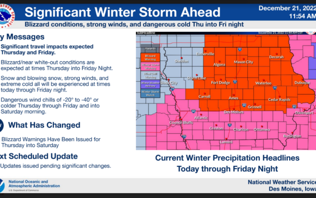
.Significant Winter Storm with Blizzard Conditions and Extreme Cold Today and Friday…
Blizzard Warning in effect Thursday through Friday night.
A region of snow is moving across central and southern Iowa very early this morning. This snow will continue to shift off to the east this morning before diminishing with the main accumulating snow done by noon. Strong northwest winds with gusts of 25 to 35 mph will be common this morning. The wind will increase more this afternoon and peak tonight and into Friday with gusts in the 40 to 50 mph range and will create blizzard conditions.
Wind chill values will fall through the day today and will be in the 20 to 40 below range before bottoming out at 35 to 45 below tonight and Friday morning.
Those with holiday travel planned through Friday night are strongly encouraged to pay close attention to forecast updates and road conditions, and prepare accordingly if travel is a must. Altering travel plans, if possible, is strongly encouraged.
…WINTER STORM WARNING REMAINS IN EFFECT UNTIL NOON CST TODAY…
…BLIZZARD WARNING REMAINS IN EFFECT FROM NOON TODAY TO 6 AM CST SATURDAY…
* WHAT…For the Winter Storm Warning, heavy snow. Additional snow accumulations of 1 to 3 inches. Winds gusting as high as 40 mph this morning. For the Blizzard Warning, blizzard conditions expected. Winds gusting as high as 50 mph or more. Extreme cold and wind chills of 20 to 40 below zero will be common and dropping to near 45 below tonight and Friday morning.
* WHERE…Much of Central and Northern Iowa along and north of Interstate 80.
* WHEN…For the Winter Storm Warning, until noon CST today. For the Blizzard Warning, from noon today to 6 AM CST Saturday.
* IMPACTS…Plan on slippery road conditions. Widespread blowing snow will significantly reduce visibility. The hazardous conditions will impact the morning or evening commute. Strong winds could bring down tree branches. The dangerously cold wind chills as low as 45 below zero could cause frostbite on exposed skin in as little as 10 minutes.
* ADDITIONAL DETAILS…The combination of blowing snow, blizzard conditions, and extreme cold will be extremely hazardous and life threatening if stranded outside.
PRECAUTIONARY/PREPAREDNESS ACTIONS…
If you must travel, keep an extra flashlight, food, and water in your vehicle in case of an emergency.
Travel should be restricted to emergencies only. If you must travel, have a winter survival kit with you. If you get stranded, stay with your vehicle.
For the latest travel conditions, check the Iowa 511 app, www.511ia.org, or dial 511.
For the latest