Blizzard Warning for north-central Iowa Thursday morning to Friday morning
February 3, 2021 6:42AM CST
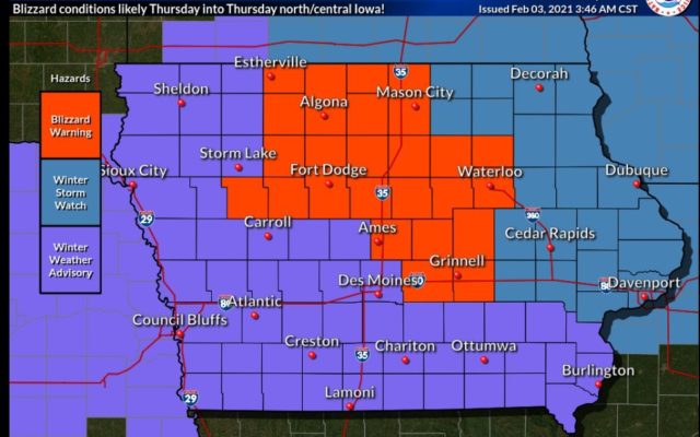
Graphic from National Weather Service-Des Moines
The following are the latest weather statements as of 6:30 Wednesday morning. For updated weather statements click on the red weather alert bar at the top of the screen
URGENT - WINTER WEATHER MESSAGE
National Weather Service Des Moines IA
335 AM CST Wed Feb 3 2021

...Significant Travel Impacts Thursday into Thursday Night...

.A powerful cold front moves through the area Thursday morning and
afternoon bringing strong northwest winds, falling temperatures,
wintry precipitation. Significant impacts to travel conditions are
likely through the rest of day into Thursday night due to a
variety of contributing factors. Scattered precipitation will
initially start as rain or drizzle tonight into Thursday morning
before the front quickly crosses the area from west to east. Any
wet or slushy roads may flash freeze and quickly become icy as
temperatures fall. Strong northwest winds gusting above 45 mph
will create widespread blowing snow and potential blizzard
conditions at times, especially in rural areas of north central
into central Iowa. Snowfall totals are not expected to be heavy,
but even light amounts may be enough to worsen impacts. Wind
chills fall below zero by Thursday evening into Thursday night,
which could serve as another hazard should motorists become
stranded. Those with travel plans are highly encouraged to closely
monitor for changing weather conditions and consider alternate
plans if at all possible. Late afternoon and evening commuters
should note that conditions may be dramatically worse compared to
the morning hours.

IAZ004>007-015>017-023>025-033>036-031745-
/O.NEW.KDMX.BZ.W.0002.210204T1200Z-210205T1200Z/
Emmet-Kossuth-Winnebago-Worth-Palo Alto-Hancock-Cerro Gordo-
Pocahontas-Humboldt-Wright-Sac-Calhoun-Webster-Hamilton-
Including the cities of Estherville, Algona, Forest City,
Lake Mills, Northwood, Manly, Emmetsburg, Garner, Britt, Kanawha,
Mason City, Clear Lake, Pocahontas, Laurens, Rolfe, Fonda,
Gilmore City, Humboldt, Eagle Grove, Clarion, Belmond, Sac City,
Lake View, Odebolt, Wall Lake, Schaller, Early, Rockwell City,
Manson, Lake City, Pomeroy, Fort Dodge, and Webster City
335 AM CST Wed Feb 3 2021

...BLIZZARD WARNING IN EFFECT FROM 6 AM THURSDAY TO 6 AM CST
FRIDAY...

* WHAT...Blizzard conditions expected. Total snow accumulations of
  2 to 4 inches. Winds gusting as high as 45 mph.

* WHERE...North central into portions of central Iowa.

* WHEN...From 6 AM Thursday to 6 AM CST Friday.

* IMPACTS...Plan on slippery road conditions. Patchy blowing snow
  could significantly reduce visibility. The hazardous conditions
  could impact the morning and evening commute.

PRECAUTIONARY/PREPAREDNESS ACTIONS...

Travel should be restricted to emergencies only. If you must
travel, have a winter survival kit with you. If you get stranded,
stay with your vehicle.

The latest road conditions for the state you are calling from can
be obtained by calling 5 1 1.


============
Franklin-Butler-Bremer-Hardin-Grundy-Black Hawk-Story-Marshall-
Tama-Jasper-Poweshiek-
Including the cities of Hampton, Parkersburg, Clarksville,
Shell Rock, Greene, Aplington, Allison, Dumont, Waverly,
Iowa Falls, Eldora, Ackley, Grundy Center, Reinbeck, Conrad,
Dike, Wellsburg, Waterloo, Cedar Falls, Ames, Marshalltown, Tama,
Toledo, Traer, Dysart, Gladbrook, Newton, and Grinnell
335 AM CST Wed Feb 3 2021

...BLIZZARD WARNING IN EFFECT FROM 9 AM THURSDAY TO 6 AM CST
FRIDAY...

* WHAT...Blizzard conditions expected. Total snow accumulations of
  2 to 4 inches. Winds gusting as high as 45 mph.

* WHERE...North central into portions of central Iowa.

* WHEN...From 9 AM Thursday to 6 AM CST Friday.

* IMPACTS...Plan on slippery road conditions. Areas of blowing
  snow could significantly reduce visibility. The hazardous
  conditions could impact the evening commute.

PRECAUTIONARY/PREPAREDNESS ACTIONS...

Travel should be restricted to emergencies only. If you must
travel, have a winter survival kit with you. If you get stranded,
stay with your vehicle.

The latest road conditions for the state you are calling from can
be obtained by calling 5 1 1.
For the latest