AFTERNOON WEATHER UPDATE — North-central Iowa braces for unprecedented mid-December storm
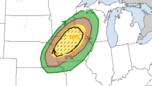
MASON CITY — An unprecedented mid-December storm is forecast to hit north-central Iowa today with non-thunderstorm high winds and the thunderstorms that could generate severe weather.
A High Wind Warning is in effect from this afternoon through the overnight hours. South-southwest winds of 30 to 40 miles per hour with gusts of 60 to 70 miles per hour are possible, with the winds becoming more westerly later this evening.
Damaging winds may blow down trees and power lines and cause power outages. Travel will be difficult, especially for high profile vehicles. People should avoid being outside, and if possible, remain in the lower levels of your home during the windstorm and avoid windows.
A line of strong to severe thunderstorms is also expected to impact the listening area late this afternoon and early this evening, with wind gusts in excess of 70 to 80 miles per hour and a few tornadoes possible.
For the latest