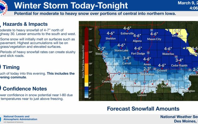
Winter Storm Warnings, Winter Weather Advisories in effect for north-central Iowa
URGENT – WINTER WEATHER MESSAGE
National Weather Service Des Moines IA
331 AM CST Thu Mar 9 2023
…Winter Storm to Impact Portions of Northern and Central Iowa Today into This Evening…
A late season winter storm will bring wintry precipitation into the state from southwest to northeast today. For southern Iowa, much of this will fall as rain with a transition toward snow into central Iowa with mainly snow over northern Iowa. Snow totals and impacts are a challenge with this winter storm due to the ground temperatures being so close to 32 degrees. The extent of roadway impacts may be mitigated by these temperatures, however higher snow rates towards an inch per hour can overcome warmer surface temperatures and still produce slick and slushy travel conditions.
Worth-Cerro Gordo-Franklin-Butler-Bremer-Hardin-Grundy-Black Hawk- Marshall-Tama-
Including the cities of Northwood, Manly, Mason City, Clear Lake, Hampton, Parkersburg, Clarksville, Shell Rock, Greene, Aplington, Allison, Dumont, Waverly, Iowa Falls, Eldora, Ackley, Grundy Center, Reinbeck, Conrad, Dike, Wellsburg, Waterloo, Cedar Falls, Marshalltown, Tama, Toledo, Traer, Dysart, and Gladbrook
331 AM CST Thu Mar 9 2023
…WINTER STORM WARNING REMAINS IN EFFECT UNTIL MIDNIGHT CST TONIGHT…
* WHAT…Snow expected. Total snow accumulations of 4 to 7 inches.
* WHERE…Portions of northern and central Iowa.
* WHEN…From 6 AM Thursday to midnight CST Thursday night.
* IMPACTS…Plan on slippery and slushy road conditions. The hazardous conditions could impact the Thursday evening commute.
PRECAUTIONARY/PREPAREDNESS ACTIONS…
If you must travel, keep an extra flashlight, food, and water in your vehicle in case of an emergency.
For the latest travel conditions, check the Iowa 511 app, www.511ia.org, or dial 511.
=========================
Mitchell-Howard-Floyd-Chickasaw-Fayette-
Including the cities of Osage, Cresco, Charles City, New Hampton, and Oelwein
305 AM CST Thu Mar 9 2023
…WINTER STORM WARNING REMAINS IN EFFECT FROM NOON TODAY TO 3 AM CST FRIDAY…
* WHAT…Heavy snow expected. Total snow accumulations of 5 to 7 inches.
* WHERE…Mitchell, Howard, Floyd, Chickasaw and Fayette Counties.
* WHEN…From noon today to 3 AM CST Friday.
* IMPACTS…Plan on slippery road conditions. Hazardous conditions could impact the evening commute.
PRECAUTIONARY/PREPAREDNESS ACTIONS…
If you must travel, keep an extra flashlight, food, and water in your vehicle in case of an emergency.
Visit 511ia.org for road conditions.
=========================
Emmet-Kossuth-Winnebago-Palo Alto-Hancock-Pocahontas-Humboldt- Wright-Sac-Calhoun-Webster-Hamilton-Crawford-Carroll-Greene-Boone- Story-Guthrie-Dallas-Polk-Jasper-Poweshiek-
Including the cities of Estherville, Algona, Forest City, Lake Mills, Emmetsburg, Garner, Britt, Kanawha, Pocahontas, Laurens, Rolfe, Fonda, Gilmore City, Humboldt, Eagle Grove, Clarion, Belmond, Sac City, Lake View, Odebolt, Wall Lake, Schaller, Early, Rockwell City, Manson, Lake City, Pomeroy, Fort Dodge, Webster City, Denison, Carroll, Jefferson, Boone, Ames, Guthrie Center, Panora, Bayard, Casey, Perry, Waukee, Adel, Des Moines, Newton, and Grinnell
331 AM CST Thu Mar 9 2023
…WINTER WEATHER ADVISORY REMAINS IN EFFECT UNTIL MIDNIGHT CST TONIGHT…
* WHAT…Snow expected. Total snow accumulations of 2 to 6 inches.
* WHERE…Portions of northern and central Iowa.
* WHEN…From 6 AM Thursday to midnight CST Thursday night.
* IMPACTS…Plan on slippery and slushy road conditions. The hazardous conditions could impact the Thursday evening commute.
PRECAUTIONARY/PREPAREDNESS ACTIONS…
Slow down and use caution while traveling.
For the latest travel conditions, check the Iowa 511 app, www.511ia.org, or dial 511.
For the latest