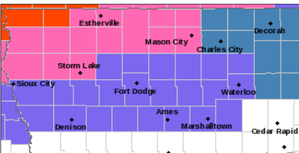
Winter Storm Warning Wednesday afternoon to Thursday night for portions of north-central Iowa
…Significant Winter Storm Potential Wednesday Into Thursday…
.A large storm system will produce hazardous winter travel
conditions from northern into central Iowa by Wednesday afternoon
and into Thursday. Potentially heavy snowfall is likely in far
northern Iowa with accumulations pushing 8 inches or more close to
the state border. Strong winds will further aggravate difficult
driving conditions by producing widespread blowing snow and
visibility reductions to near a quarter mile at times. Mixed
precipitation types are more of a concern to the south in central
Iowa with a variety of snow, freezing rain, and sleet all
possible. Ice accretions may approach a quarter inch over portions
of central Iowa should more freezing rain be realized.
IAZ004>007-015>017-211700-
/O.UPG.KDMX.WS.A.0004.230222T1200Z-230223T1800Z/
/O.NEW.KDMX.WS.W.0004.230222T1800Z-230224T0000Z/
Emmet-Kossuth-Winnebago-Worth-Palo Alto-Hancock-Cerro Gordo-
Including the cities of Estherville, Algona, Forest City,
Lake Mills, Northwood, Manly, Emmetsburg, Garner, Britt, Kanawha,
Mason City, and Clear Lake
247 AM CST Tue Feb 21 2023
…WINTER STORM WARNING IN EFFECT FROM NOON WEDNESDAY TO 6 PM CST
THURSDAY…
* WHAT…Heavy mixed precipitation expected. Total snow
accumulations of 4 to 10 inches and ice accumulations of around
one tenth of an inch. Highest snow totals near the state border. Winds
gusting as high as 40 mph.
* WHERE…Far north central Iowa.
* WHEN…From noon Wednesday to 6 PM CST Thursday.
* IMPACTS…Travel could be very difficult. Patchy blowing snow
could significantly reduce visibility. The hazardous
conditions could impact the morning or evening commute.
PRECAUTIONARY/PREPAREDNESS ACTIONS…
If you must travel, keep an extra flashlight, food, and water in
your vehicle in case of an emergency.
For the latest travel conditions, check the Iowa 511 app,
www.511ia.org, or dial 511.
For the latest