UPDATED — Winter Storm Warning 6:00 PM tonight through Tuesday evening — 5-9 inches of snow forecast
February 11, 2019 5:03AM CST
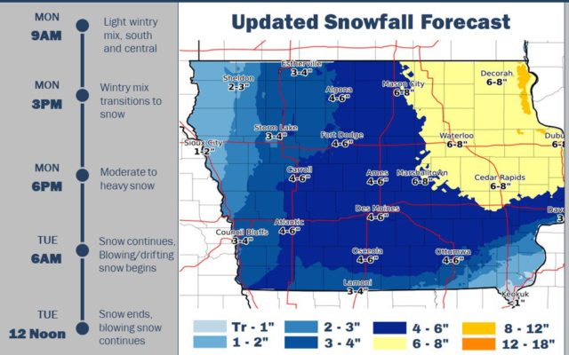
MASON CITY — Another winter storm is forecast to bear down on north-central Iowa this evening through Tuesday evening. Some locations are forecast to receive up to nine inches of snow by the end of the day Tuesday. Here’s information from the National Weather Service as of 11:40 AM Monday morning. For updated information, click on one of the following links, or click on the red weather alert bar at the top of this page for the latest weather statements:
National Weather Service-Des Moines — latest “Situation Report”
National Weather Service-Des Moines main page
Winnebago-Worth-Hancock-Cerro Gordo-Wright-Franklin-Butler-Bremer-
Including the cities of Forest City, Lake Mills, Northwood,
Manly, Garner, Britt, Kanawha, Mason City, Clear Lake,
Eagle Grove, Clarion, Belmond, Hampton, Parkersburg, Clarksville,
Shell Rock, Greene, Aplington, Allison, Dumont, and Waverly
1136 AM CST Mon Feb 11 2019

...WINTER STORM WARNING NOW IN EFFECT FROM 6 PM THIS EVENING TO
6 PM CST TUESDAY...

* WHAT...Heavy snow expected. Total snow accumulations of 3 to 6
  inches and a light glaze of ice expected. On Tuesday, winds
  gusting as high as 40 mph may lead to blowing and drifting snow.

* WHERE...Northern Iowa.

* WHEN...From 6 PM this evening to 6 PM CST Tuesday.

* ADDITIONAL DETAILS...Travel could be very difficult. Patchy
  blowing snow could significantly reduce visibility. The
  hazardous conditions could impact the morning or evening
  commute.

PRECAUTIONARY/PREPAREDNESS ACTIONS...

A Winter Storm Warning means significant amounts of snow, sleet
and ice will make travel very hazardous.

The latest road conditions for the state you are calling from can
be obtained by calling 5 1 1.
=========
Mitchell-Howard-Winneshiek-Allamakee-Floyd-Chickasaw-Fayette-
Clayton-Dodge-Olmsted-Winona-Mower-Fillmore-Houston-Crawford-
Grant-
Including the cities of Osage, Cresco, Decorah, Waukon,
Charles City, New Hampton, Oelwein, Elkader, Dodge Center,
Rochester, Winona, Austin, Preston, Caledonia, Prairie Du Chien,
and Platteville
727 AM CST Mon Feb 11 2019

...WINTER STORM WARNING REMAINS IN EFFECT FROM 6 PM THIS EVENING
TO 9 PM CST TUESDAY...

* WHAT...Heavy snow expected. Total snow accumulations of 6 to 9
  inches expected. Winds gusting as high as 35 mph will likely
  produce some blowing and drifting of snow as well Tuesday
  afternoon into Tuesday evening.

* WHERE...Portions of southwest Wisconsin, north central and
  northeast Iowa and southeast Minnesota.

* WHEN...From 6 PM this evening to 9 PM CST Tuesday.

* ADDITIONAL DETAILS...Travel could be very difficult to
  treacherous. Patchy blowing snow could significantly reduce
  visibility. The hazardous conditions will likely impact the
  morning or evening commute.

PRECAUTIONARY/PREPAREDNESS ACTIONS...

A Winter Storm Warning for snow means severe winter weather
conditions will make travel very hazardous or impossible. If you
must travel, keep an extra flashlight, food and water in your
vehicle in case of an emergency.

The latest road conditions for Iowa can be found on-line at
511ia.org, in Minnesota at 511mn.org, and in Wisconsin at
511wi.gov or by calling 5 1 1.
For the latest