WINTER STORM WARNING in effect until 6:00 PM CST Saturday for the entire listening area.
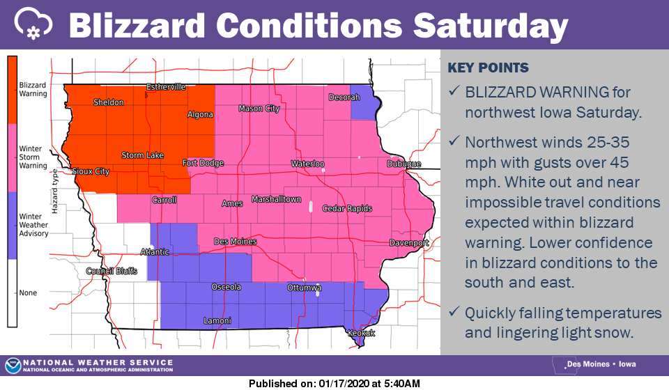
…WINTER STORM WARNING IN EFFECT UNTIL 6 PM CST SATURDAY FOR CERRO GORDO, WORTH, WINNEBAGO, HANCOCK, KOSSUTH, WRIGHT, FRANKLIN AND BUTLER COUNTIES..
* WHAT…Snow this afternoon transitioning to mixed precipitation expected overnight. Total snow accumulations of 3 to 5 inches and ice accumulations of around one tenth of an inch. Winds gusting as high as 45 mph.
* WHERE…North-Central Iowa.
* WHEN…Until 6 PM CST Saturday.
* IMPACTS…Plan on slippery road conditions. Areas of blowing snow could significantly reduce visibility. The hazardous conditions could impact the evening commute. Gusty winds could bring down tree branches and impact power lines.
PRECAUTIONARY/PREPAREDNESS ACTIONS… If you must travel, keep an extra flashlight, food, and water in your vehicle in case of an emergency. The latest road conditions for the state you are calling from can be obtained by calling 5 1 1.
…WINTER STORM WARNING IN EFFECT UNTIL 6 PM SATURDAY FOR FLOYD, MITCHELL AND MOWER MN.
* WHAT…Heavy snow this afternoon changing to a wintry mix tonight and then light snow on Saturday morning. Total snow accumulations of 4 to 6 inches and ice accumulations up to one tenth of an inch. Winds gusting as high as 45 mph which will cause blowing and drifting snow on Saturday.
* WHERE…Chickasaw, Floyd and Mitchell Counties.
* WHEN…From 11 AM this morning to 6 PM CST Saturday.
* IMPACTS…Plan on slippery road conditions. Blowing snow could significantly reduce visibility. The hazardous conditions will impact the evening commute.
PRECAUTIONARY/PREPAREDNESS ACTIONS… If you must travel, keep an extra flashlight, food, and water in your vehicle in case of an emergency. The latest road conditions for the state you are calling from can be obtained by calling 5 1 1.
A WINTER STORM WARNING IS IN EFFECT FOR FREEBORN AND FARIBAULT COUNTIES UNTIL 6 PM SATURDAY.
* WHAT…Heavy snow expected on Friday. The snow may mix with freezing drizzle for a time Friday night in south central Minnesota. Total snow accumulations of 5 to 8 inches and ice accumulations of a light glaze. Winds this afternoon will be 25 to 30 mph causing poor visibility in the snow. On Saturday, northwest winds will gust as high as 45 mph with poor visibility in the blowing snow.
* WHERE…Portions of central, south central and west central Minnesota. Generally from Alexandria to Hutchinson to Albert Lea.
* WHEN…The warning is from 10 AM Friday to 6 PM CST Saturday. The snow will fall on Friday, and the strong winds with poor visibility will develop on Saturday.
* IMPACTS…Travel could be very difficult. Areas of blowing snow could significantly reduce visibility. The hazardous conditions will impact the Friday evening commute.
PRECAUTIONARY/PREPAREDNESS ACTIONS… If you must travel, keep an extra flashlight, food, and water in your vehicle in case of an emergency. The latest road conditions for the state you are calling from can be obtained by calling 5 1 1.
A BLIZZARD WARNING IS IN EFFECT FROM 6 AM TO 6 PM CST SATURDAY FOR HUMBOLDT AND KOSSUTH COUNTES…
* WHAT…For the Winter Storm Warning, Snow this afternoon transitioning to mixed precipitation expected overnight. Total
snow accumulations of 3 to 5 inches and ice accumulations of around one tenth of an inch. Winds gusting as high as 45 mph.
For the Blizzard Warning, blizzard conditions expected. Winds gusting as high as 50 mph.
* WHERE…Northern Iowa.
* WHEN…For the Winter Storm Warning, from 9 AM this morning to 6 AM CST Saturday. For the Blizzard Warning, from 6 AM to 6 PM CST Saturday.
* IMPACTS…Plan on slippery road conditions. Areas of blowing snow could significantly reduce visibility. The hazardous
conditions could impact this evening commute. Gusty winds could bring down tree branches and impact power lines.
* ADDITIONAL DETAILS…Occasional blizzard to near-blizzard conditions are possible in northern Iowa during periods of
heavier snow this afternoon into the early evening.
PRECAUTIONARY/PREPAREDNESS ACTIONS…
If you must travel, keep an extra flashlight, food, and water in your vehicle in case of an emergency.
Travel should be restricted to emergencies only. If you must travel, have a winter survival kit with you. If you get stranded,
stay with your vehicle.
The latest road conditions for the state you are calling from can be obtained by calling 5 1 1.

For the latest