Storm expected to dump snow across north-central Iowa tonight
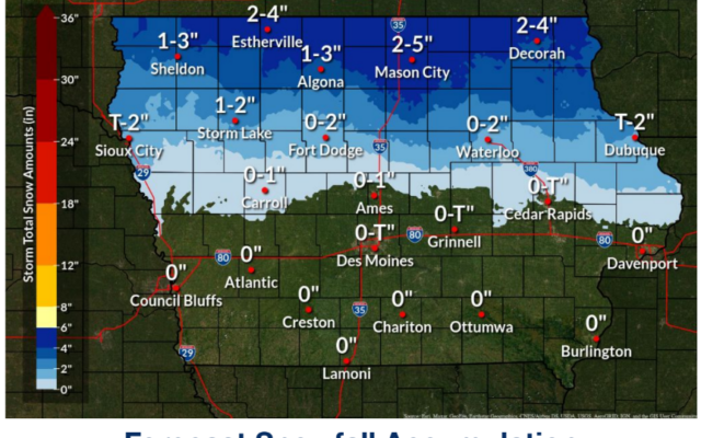

National Weather Service graphics showing forecast snowfall and ice accumulation
A broad swath of precipitation will overspread the state this afternoon and evening. Temperatures near to below freezing will favor wintry precipitation types over northern into western Iowa. The bulk of the snowfall accumulations are expected across northern Iowa, where 3 to 5 inches should be common by late Friday morning. The snow will create areas of hazardous travel conditions due to slick and covered roads along with visibility reductions. Just to the south, roughly between State Highway 3 and US Highway 30, a glaze of ice mixed in with the snow is possible. This would lead to slick conditions, particularly on elevated surfaces such as bridges and overpasses.
IAZ005>007-016-017-025>028-039-081730-
/O.EXT.KDMX.WW.Y.0017.221209T0000Z-221209T1500Z/
Kossuth-Winnebago-Worth-Hancock-Cerro Gordo-Wright-Franklin-
Butler-Bremer-Black Hawk-
Including the cities of Algona, Forest City, Lake Mills, Northwood, Manly, Garner, Britt, Kanawha, Mason City, Clear Lake, Eagle Grove, Clarion, Belmond, Hampton, Parkersburg, Clarksville, Shell Rock, Greene, Aplington, Allison, Dumont, Waverly, Waterloo, and Cedar Falls
321 AM CST Thu Dec 8 2022
…WINTER WEATHER ADVISORY NOW IN EFFECT FROM 6 PM THIS EVENING
TO 9 AM CST FRIDAY…
* WHAT…Mixed precipitation expected. Total snow accumulations of 2 to 5 inches and ice accumulations of around one tenth of an inch. Highest snow accumulations toward the Minnesota border.
* WHERE…North Central Iowa.
* WHEN…From 6 PM this evening to 9 AM CST Friday.
* IMPACTS…Plan on slippery road conditions. The hazardous conditions could impact this evening`s commute as well as Friday morning`s commute.
PRECAUTIONARY/PREPAREDNESS ACTIONS…
Slow down and use caution while traveling.
For the latest travel conditions, check the Iowa 511 app, www.511ia.org, or dial 511.
For the latest