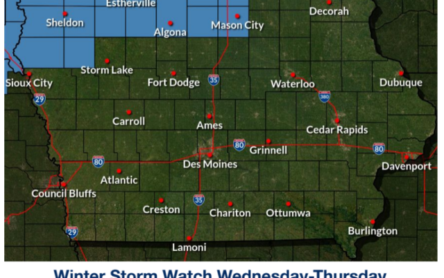
Significant Winter Storm forecast for north-central Iowa Wednesday
…Significant Winter Storm with Two Rounds of Precipitation…
.A large winter storm with prolonged wintry precipitation will
occur over the region Tuesday through Thursday. The first round
will be mainly snow over far northern Iowa with light
accumulations possible. Otherwise with this first round, much of
Iowa will not see any wintry precipitation.
The second round of wintry precipitation Wednesday into Thursday
will be more widespread and be the more impactful portion of this
winter storm for the state of Iowa. That is what this Winter
Storm Watch covers and additional headlines and areas covered are
certainly possible in the coming days. While snow will remain the
main precipitation type over northern Iowa, a wintry mix with
icing potential is possible between Highway 30 and 3. Farther
south for areas south of I-80, mainly rain is expected that may
end as a bit of light snow with little if any accumulation.
Wednesday into Thursday will also feature strong and gusty winds,
which will cause areas of blowing snow over northern Iowa.
Needless to say, travel impacts are increasingly likely Wednesday
into Thursday over northern into parts of central Iowa and
certainly for areas of South Dakota, Minnesota, and Wisconsin as
well.
IAZ004>007-015>017-201800-
/O.NEW.KDMX.WS.A.0004.230222T1200Z-230223T1800Z/
Emmet-Kossuth-Winnebago-Worth-Palo Alto-Hancock-Cerro Gordo-
Including the cities of Estherville, Algona, Forest City,
Lake Mills, Northwood, Manly, Emmetsburg, Garner, Britt, Kanawha,
Mason City, and Clear Lake
356 AM CST Mon Feb 20 2023
…WINTER STORM WATCH IN EFFECT FROM WEDNESDAY MORNING THROUGH
THURSDAY MORNING…
* WHAT…Heavy mixed precipitation possible. Total snow
accumulations of 4 to 10 inches with the highest accumulations
possible near the Minnesota border over northwest Iowa. Ice
accumulations up to around one tenth of an inch possible. Winds
could gust as high as 45 mph.
* WHERE…Northern Iowa.
* WHEN…From Wednesday morning through Thursday morning.
* IMPACTS…Travel could be very difficult. Areas of blowing snow
could significantly reduce visibility. The hazardous conditions
could impact the Wednesday and Thursday morning and evening
commutes. Gusty winds could bring down tree branches.
* ADDITIONAL DETAILS…Light snow is possible Tuesday into Tuesday
night, which is not a part of this current watch.
PRECAUTIONARY/PREPAREDNESS ACTIONS…
Monitor the latest forecasts for updates on this situation.
&&
$$
For more information from the National Weather Service visit
http://weather.gov/desmoines
For the latest