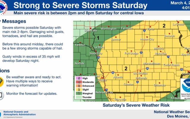
Saturday may bring severe storms & 70s, while snow is possible late Sunday
MASON CITY — The rollercoaster ride of Iowa weather will take another sharp curve and a dip this weekend.
Meteorologist Andrew Ansorge, with the National Weather Service, says today should be warmer and relatively quiet, but tomorrow, there could be powerful thunderstorms.
“We’re looking at the chance for strong to severe storms probably in the 2 to 8 PM time period on Saturday afternoon and evening,” Ansorge says, “and with that, damaging wind gusts, tornadoes and hail will all be possible.”
In the past week, Iowa’s seen high temperatures in the 70s and lows in the teens. After Saturday’s warm front passes, Sunday will be much cooler with the chance of more snow on Sunday night.
“That still looks like it’s on track for especially southern Iowa but as we get into northern Iowa, there’s still a discrepancy in the models at this time,” Ansorge says. “Some models are painting snow across much of the state but others are showing snow just over extreme southeastern Iowa.”
The climatological winter ended this past Monday, while astronomical spring arrives in a little over two weeks, on March 20th.
For the latest