North-central Iowa continues to prepare for pre-Christmas winter storm
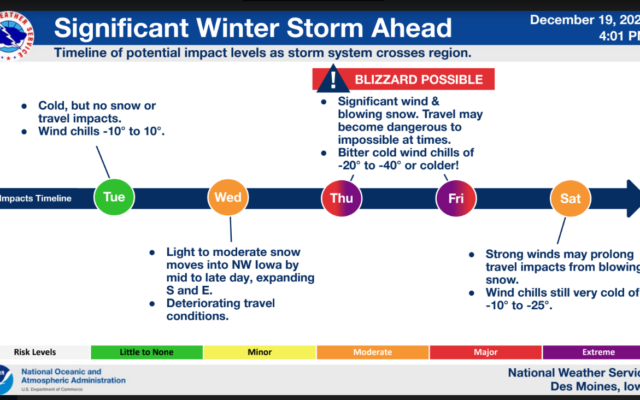
A powerful winter storm will impact the region late Wednesday through Friday. A significant multi-faceted event is expected, including the potential for concurrent blizzard conditions and extreme cold. Travel could be dangerous to near impossible at times Thursday and Friday. Extreme cold is expected as well with wind chills falling to 20 to 40 below zero or colder from late Thursday through the end of the week.
Those with holiday travel planned from late Wednesday through Friday are strongly encouraged to pay close attention to forecast updates and road conditions, and prepare accordingly if travel is a must. Altering travel plans, if possible, is strongly encouraged.
347 AM CST Tue Dec 20 2022
…WINTER STORM WATCH REMAINS IN EFFECT FROM WEDNESDAY EVENING THROUGH LATE FRIDAY NIGHT…
* WHAT…Blizzard conditions possible. Total snow accumulations of 3 to 6 inches, with locally higher amounts possible. Wind gusts of 40 to 50 mph or greater may occur late Thursday through Friday. Extreme cold and wind chills of 20 to 40 below will be common.
* WHERE…All of central Iowa
* WHEN…From Wednesday evening through late Friday night. Snow late Wednesday into Thursday. Strong winds and extreme cold Thursday into Friday.
* IMPACTS…Plan on slick and snow covered road conditions. Blowing snow and possible blizzard conditions may reduce visibilities to near zero at times. The dangerously cold wind chills as low as around 40 below zero could cause frostbite on exposed skin in as little as 10 minutes.
PRECAUTIONARY/PREPAREDNESS ACTIONS…
Prepare for possible blizzard conditions. Continue to monitor the latest forecasts for updates on this situation.
For the latest