Another round of winter weather, frigid temperatures coming Wednesday into Thursday night
February 6, 2019 6:44AM CST

MASON CITY — Winter Weather Advisories are in effect from this afternoon through Thursday night for our listening area. Here’s the latest statements as of 6:45 this morning. You can find updates here.
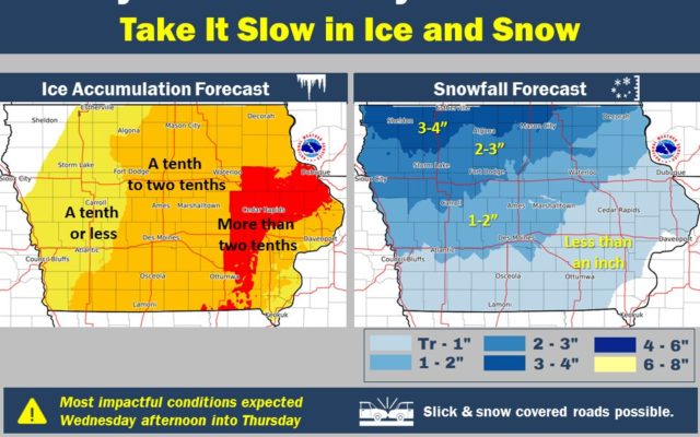
...Wintry Weather Today into Thursday Evening...

.Another winter system will affect Iowa from today into Thursday
evening with a combination of freezing rain, freezing drizzle and
snow. There will be breaks and periods of lighter precipitation
during the entire event, but the combination of a frozen mix and
moderate ice and snow accumulations will make for difficult travel
at times. Following the storm Thursday night, another round of
Arctic cold will invade the region.

IAZ004>007-016-017-025-026-061800-
/O.CON.KDMX.WW.Y.0012.190206T2100Z-190208T0600Z/
Emmet-Kossuth-Winnebago-Worth-Hancock-Cerro Gordo-Wright-Franklin-
Including the cities of Estherville, Algona, Forest City,
Lake Mills, Northwood, Manly, Garner, Britt, Kanawha, Mason City,
Clear Lake, Eagle Grove, Clarion, Belmond, and Hampton
347 AM CST Wed Feb 6 2019

...WINTER WEATHER ADVISORY REMAINS IN EFFECT FROM 3 PM THIS
AFTERNOON TO MIDNIGHT CST THURSDAY NIGHT...

* WHAT...Mixed precipitation expected. Total snow accumulations of
  2 to 5 inches and ice accumulations of one tenth to two tenths
  of an inch expected. Winds gusting as high as 35 mph by late
  morning Thursday producing blowing snow.

* WHERE...Portions of Northern Iowa.

* WHEN...From 3 PM Wednesday to midnight CST Thursday night.

* ADDITIONAL DETAILS...Plan on slippery road conditions. Areas
  of blowing snow could significantly reduce visibility. The
  hazardous conditions could impact the morning or evening
  commute. The cold wind chills as low as 30 below zero could
  cause frostbite on exposed skin in as little as 30 minutes.

PRECAUTIONARY/PREPAREDNESS ACTIONS...

The latest road conditions for the state you are calling from can
be obtained by calling 5 1 1.

=========
Mitchell-Howard-Winneshiek-Allamakee-Floyd-Chickasaw-Fayette-
Clayton-Grant-
Including the cities of Osage, Cresco, Decorah, Waukon,
Charles City, New Hampton, Oelwein, Elkader, and Platteville
312 AM CST Wed Feb 6 2019

...WINTER WEATHER ADVISORY IN EFFECT FROM 3 PM THIS AFTERNOON TO
6 PM CST THURSDAY...

* WHAT...A wintry mix of snow, sleet, and freezing drizzle this
  afternoon transitioning to freezing rain tonight and to snow on
  Thursday. Total ice accumulation of one-tenth to two-tenths of
  an inch tonight, with snow accumulation Thursday of 1 to 3
  inches expected. Winds gusting as high as 35 mph Thursday
  afternoon.

* WHERE...Portions of southwest Wisconsin and northeast Iowa.

* WHEN...From 3 PM this afternoon to 6 PM CST Thursday.

* ADDITIONAL DETAILS...Travel is likely to be heavily impacted due
  to icy conditions tonight and snow on Thursday. The hazardous
  conditions could impact the evening commute today, and will
  impact Thursday`s commutes.

PRECAUTIONARY/PREPAREDNESS ACTIONS...

A Winter Weather Advisory means that periods of snow, sleet or
freezing rain will cause travel difficulties. Expect slippery
roads and limited visibilities, and use caution while driving.

The latest road conditions for Iowa can be found on-line at
511ia.org, in Minnesota at 511mn.org, and in Wisconsin at
511wi.gov or by calling 5 1 1.
For the latest